Dublin, Nov. 27, 2023 (GLOBE NEWSWIRE) -- The "U.S. Geospatial Imagery Analytics Market - A Regional Analysis: Focus on Application and Solution - Analysis and Forecast, 2023-2033" report has been added to ResearchAndMarkets.com's offering.
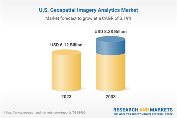
The U.S. geospatial imagery analytics market is estimated to reach $8.38 billion in 2033, reveals the premium market intelligence study. The study also highlights that the market is set to witness a CAGR of 3.19% during the forecast period 2023-2033.
The factors attributing to the growth of the market include the rise in the adoption of emerging technologies, increasing demand for small satellites, and the overall growth of the U.S. geospatial imagery analytics market.
The U.S. geospatial imagery analytics market has experienced remarkable growth in recent years due to the increasing use of geospatial technologies in various industries such as transportation, agriculture, maritime, and defense.
The widespread adoption of artificial intelligence (AI), machine learning (ML), and cloud computing geospatial technologies led to the growth of geospatial imagery analytics in the U.S. Regional organizations are consuming large amounts of data generated through remote sensing, geographic information systems (GIS), global positioning systems (GPS), and internal mapping technologies.
For instance, in February 2023, IBM and the National Aeronautics and Space Administration (NASA)' Marshall Space Flight Center signed a collaboration to use artificial intelligence (AI) to process geospatial data quickly. The partnership includes the integration of AI with large datasets from NASA's Earth observation satellites for quicker and easier climate research analysis.
The U.S. geospatial imagery analytics market is characterized by intense competition, with several key players operating in the industry. Notable companies include BENTLEY SYSTEMS, INCORPORATED, BlackSky Technology Inc., Esri, Maxar Technologies Inc., and others. These companies heavily invest in research and development to introduce innovative products.
The market also features smaller and medium-sized companies offering specialized products. With the increasing demand for geospatial imagery analytics, the market is anticipated to experience significant growth in the coming years as more industries recognize the benefits of utilizing services such as remote sensing, environmental monitoring, infrastructure, and asset management.
The market can be segmented based on application and product, and it is expected to witness continued growth as key players and defense forces invest in advanced technologies to enhance performance and effectiveness, leading to new opportunities for growth and innovation in the sector.
Introduction to the U.S. Geospatial Imagery Analytics
New technologies, such as machine learning (ML) and artificial intelligence (AI), enable businesses and government organizations to analyze large amounts of data in real time for better decision-making. ML and AI algorithms excel in pattern recognition, predictive analysis, and automation, providing valuable insights, optimizing operations, and enhancing overall efficiency.
This digital revolution is not only enhancing decision-making processes but also shaping the future of industries across various sectors, including healthcare, finance, transportation, and more. Furthermore, high-resolution satellite images and geospatial data are becoming more widely available, which is one of the factors driving the growth of the market.
Furthermore, the rise in deployment of small-satellite constellations in the U.S. by various companies such as Capella Space, Descartes Labs, Inc., and Planet Labs PBC are capable of cost-effective geospatial solutions. The regional companies have access to high-resolution satellite imagery data through the Earth observation satellites in orbit.
There are approximately 1,000 Earth observation satellites, out of which more than 600 of these satellites are being operated by the U.S. Hence, deploying more satellites has decreased the satellite imagery acquisition cost and made it more affordable for geospatial services.
Furthermore, the region is collaborating with commercial geospatial service providers through contracts and partnerships for intelligence and defense needs. For instance, in March 2023, Planet Labs PBC announced that its wholly owned subsidiary, Planet Labs Federal, Inc., secured a contract from the National Reconnaissance Office (NRO) under the Strategic Commercial Enhancements (SCE) Broad Agency Announcement (BAA) program, with a specific focus on Commercial Hyperspectral Capabilities (CHC).
Industrial Impact
The U.S. geospatial imagery analytics market is witnessing rapid growth due to the growing demand for integrated domain awareness solutions, the deployment of small-satellite constellations, and the need for real-time data for surveillance or commercial purposes.
The increasing deployment of small satellites for Earth observation applications is another factor that is driving the geospatial imagery analytics in the region. In 2022, the region contributed more than 140 Earth observation satellites in orbit. The high-resolution remote sensing data is utilized by various geospatial imagery analytics providers for offering solutions to commercial and government organizations.
For instance, Planet Labs PBC, a satellite imagery data provider, manages terabytes of satellite datasets through its satellite constellation of more than 150 satellites. The company provides satellite imagery data access to users through its web-based tools, such as the application programming interface (API). However, compliance with regulations and international agreements regarding the collection, storage, and use of geospatial data can be complex and may vary by region.
Market Segmentation
Construction and Infrastructure Development in Application Section to Dominate the U.S. Geospatial Imagery Analytics Market
The construction and infrastructure development segment of the U.S. geospatial imagery analytics market is estimated to be $0.88 billion in 2022 and is expected to grow up to $1.34 billion by 2033, growing at a CAGR of 4.07%. The Building Information Modeling (BIM) industry's rapid evolution caused a significant impact on both the construction and the design industries.
BIM and GIS integration development brings a new way of thinking about construction and planning. This process includes a transition from 2D to 3D, building information modeling on the digital front. Additionally, GIS data is required to plan various infrastructure operations such as roads, trains, and airports.
Analytics in Product Section to Dominate the U.S. Geospatial Imagery Analytics Market by Solution
The U.S. geospatial imagery analytics market is expected to be dominated by analytics in 2023, with $2.57 billion in 2022 in terms of revenue, and is expected to reach $3.57 billion in 2033. In this market, there are companies such as Orbital Insight that offer AI-powered software platforms.
The Orbital Insight platform can perform analytics using a variety of geospatial data sources, including satellite and aerial images, location data, automatic identification system (AIS) data, and more. Similarly, EOS Data Analytics, a cloud-based solutions provider, offers the EOSDA platform for tasks such as crop monitoring, land observation, and forest monitoring. This platform leverages deep learning algorithms to analyze satellite imagery and deliver actionable insights.
Key Market Players and Competition Synopsis
Key players in the U.S. geospatial imagery analytics market analyzed and profiled in the study involve major U.S. geospatial imagery analytics companies providing solutions, respectively.
Moreover, a detailed market share analysis of the players operating in the U.S. geospatial imagery analytics market has been done to help the reader understand how players stack against each other, presenting a clear market landscape. Additionally, comprehensive competitive strategies such as partnerships, agreements, and collaborations will aid the reader in understanding the untapped revenue pockets in the market.
Key Attributes:
| Report Attribute | Details |
| No. of Pages | 227 |
| Forecast Period | 2023 - 2033 |
| Estimated Market Value (USD) in 2023 | $6.12 Billion |
| Forecasted Market Value (USD) by 2033 | $8.38 Billion |
| Compound Annual Growth Rate | 3.2% |
| Regions Covered | United States |
Markets Dynamics
Industry Outlook
- U.S. Geospatial Imagery Analytics Market: Overview
- Growing Integrated Domain Awareness Solutions Market
- Access to New and Cheaper Data Sets
- Impact of the Growing Small Satellite Market
- Evolving Customer Requirements across Key Applications
Market Developments and Technology Trends
- Emerging EO/SAR Data from Small-Satellite Missions
- Aggregator Business Models Providing Access to Diverse Data Sources
- Emerging Drone-Based Imagery Solutions
- Artificial Intelligence (AI)/Machine Learning (ML)
- 3D Modeling/Digital Twin
Business Drivers
- Increasing Deployment of Artificial Intelligence Capabilities
- Growing Need for Data-Driven Decision-Making across Market
Business Strategies
- New Product Launches
- Startup and Investment Scenarios
Corporate Strategies
- Partnerships, Collaborations, Agreements, and Contracts
- Mergers and Acquisitions
Business Opportunities
- Increasing Use of Geospatial Data to Create Sustainable Solutions
Business Challenges
- Increasing Competition Due to Fragmented Market as a Result of Multiple Startups
- Evolving Trend of Upstream Participants Delivering Downstream Services
Global Geospatial Imagery Analytics Market Scenario
- Russia
- Recent Developments in Russia
- Key Manufacturers and Geospatial Imagery Analytics Providers in Russia
- U.K.
- China
- Japan
- Middle East and Africa
Key Geospatial Use Cases
- Maritime
- Agriculture
- Defense
- Healthcare
- Oil and Gas
Market Share Analysis & Company Profiles
- Albedo Space Corp.
- AllSource Analysis
- AiDash
- BENTLEY SYSTEMS, INCORPORATED
- BlackSky Technology Inc.
- Capella Space
- DataCapable Inc.
- Esri
- EOS Data Analytics, Inc.
- GreenValley International
- Keystone Aerial Surveys, Inc.
- Locana
- Maxar Technologies Inc.
- Michael Baker International
- NextNav Inc.
- Planet Labs PBC
- Spire Global, Inc.
- Swift Navigation, Inc.
- TerraGo Technologies
- The Sanborn Map Company, Inc.
- Trimble Inc.
- Unearth Labs
- Umbra Lab Inc.
- VETRO FiberMap
- VORTICS IMAGING
- Weather Stream Inc.
- Zonda
For more information about this report visit https://www.researchandmarkets.com/r/aw94wy
About ResearchAndMarkets.com
ResearchAndMarkets.com is the world's leading source for international market research reports and market data. We provide you with the latest data on international and regional markets, key industries, the top companies, new products and the latest trends.
Attachment
