Contact Information: Media Contact: Alan Penchansky The Pen Group (305) 529-1944 alan@thepengroup.com
Blue Dasher Technologies Begins Street-Level Image Capture of Phoenix Metropolitan Area
Company's Fleet of Advanced Image Capture Vehicles to Traverse All Local Streets and Highways in Maricopa County
| Source: Blue Dasher Technologies
MIAMI, FL--(Marketwire - February 19, 2009) - Blue Dasher Technologies today announced that the
Phoenix, Arizona metropolitan region is being added to its database of
high-density 360-degree street-level images. The company's database of
panoramic images of major U.S. population centers is licensed to
third-party providers of commercial, industrial, government and consumer
applications.
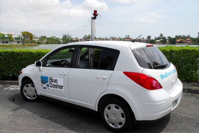
Blue Dasher's fleet of image capture vehicles will photograph every public
street and highway in Phoenix, Scottsdale, and throughout Maricopa County
during February. Launched in 2008, Blue Dasher has created the most
advanced searchable database that allows users to explore and navigate a
neighborhood from their PC.
Blue Dasher's image capture vehicles are equipped with digital camera
arrays and sophisticated proprietary software for image geo-coding.
Because images are recorded every eight to ten feet, the result is
high-density photography that gives users unparalleled accuracy. When
viewed online, the 360-degree images from Blue Dasher Technologies are
seamless, creating an experience similar to driving down the street.
In addition, with Blue Dasher, users have access to exact addresses, which
results in a much more useful tool for a host of applications, from
economic development, commercial real estate research, zoning and code
enforcement, and residential real estate assessment, to consumer
applications, such as planning a trip online.
"Our street-level image technology was designed from the ground up to
deliver a superior solution to both businesses and government agencies,"
said Michael Reidbord, president & CEO, Blue Dasher Technologies. "We
continue to add metro areas across the country, and as elsewhere, are
driving every single street in Maricopa County, including all 24
municipalities."
Blue Dasher is currently licensing its database of major metropolitan areas
in several states including Florida, California, Nevada and Colorado.
Blue Dasher Technologies draws on more than 20 years of work in the GIS and
real estate industries. Previous companies founded by Blue Dasher
principals built GIS solutions for the oil and gas industry and state and
local governments, including the Port Authority of New York and New Jersey,
Los Alamos National Laboratory, and the states of Louisiana and Florida.
Blue Dasher Technologies
Founded in 2007, Blue Dasher Technologies provides high quality, geo-coded,
street-level, panoramic imagery and advanced image viewing technology.
Expanding beyond the capabilities of first generation street-level imaging,
Blue Dasher's patented technology delivers exact address matching and
high-density photography that enables a realistic street drive. These
features enable buildings and properties to be pinpointed for increased
efficiency and permit
true-to-life tours of residential and commercial areas. In addition,
licensees have the ability to embed detailed information, such as
multimedia, property data, or advertising into specific points within a
geographic area. The company is based in Miami and is privately held. More
information, including online demos, may be viewed at
www.BlueDasherTech.com.