
Source: MacDonald Mines Exploration Ltd.
Red Pine Reports on Wawa Gold Project Assay Results and Commences 2015 Drill Program
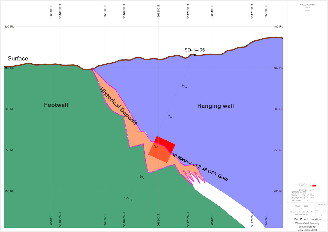
Hole 5 - 30.64 Metres of 3.38 g/t Gold including 7.25 Metres of 12.94 g/t
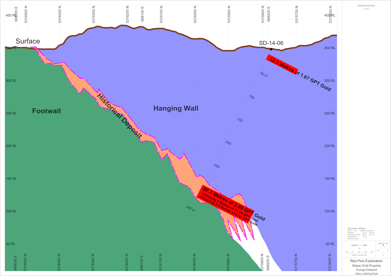
Hole 6 - 27.67 Metres of 2.89 g/t Gold including 4.00 Metres of 11.54 g/t
TORONTO, ONTARIO--(Marketwired - Feb. 10, 2015) - Red Pine Exploration Inc. (TSX VENTURE:RPX) (the "Company" or "Red Pine") drilled six exploration holes on the Surluga Gold Deposit in December 2014. Full assay results have now been received for holes SD-14-05 and SD-14-06 and final results for hole SD14-04 are expected shortly.
Significant assay results for holes SD14-05 and SD-14-06 are summarized below:
| Grams per tonne ("g/t") |
||||
| Hole ID | From (m) | To (m) | Length* (m) | Gold (g/t) |
| SD-14-05 | 134.86 | 165.50 | 30.64 | 3.38 |
| incl. | 155.00 | 162.50 | 7.25 | 12.94 |
| SD-14-06 | 10.61 | 22.72 | 12.11 | 1.67 |
| SD-14-06 | 294.83 | 322.5 | 27.67 | 2.89 |
| incl. | 301.1 | 304.4 | 3.30 | 6.52 |
| incl. | 318.5 | 322.5 | 4.00 | 11.54 |
*Lengths reported above in metres ("m") are drill intersected core and do not represent true widths.
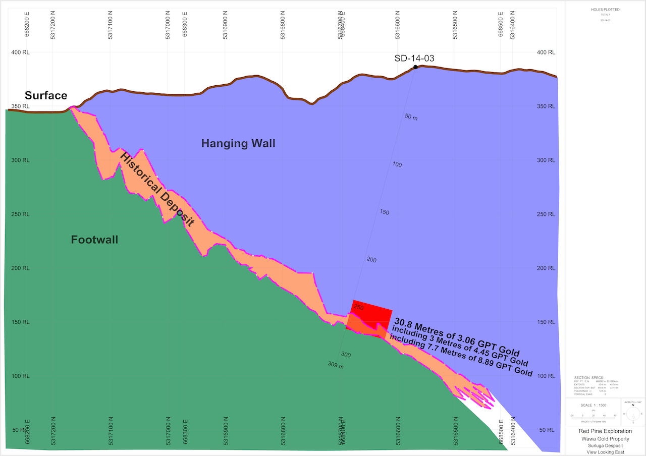
Quentin Yarie, President and COO of Red Pine, commented, "These results validate our theory that high-grade shoots of gold mineralization are prevalent within the Surluga Gold Deposit. Gold grades over substantial intersections such as those reported in holes SD-14-03, SD-14-05 and SD-14-06 present new opportunities, and we will look to further define these high-grade areas as we continue to advance our project. "
2014 Drilling Program
Red Pine's December 2014 exploration program was conducted to confirm gold grades in the historical underground drill holes at Surluga and to better define the constrained morphology and underlying structural controls of the high grade gold mineralization zones of the deposit.
The underground drilling results were not incorporated in the current resource calculation for the Surluga Deposit. Given this fact, the location of the six drill holes were selected to both intersect historic gold mineralization, and identify the orientation of gold-bearing horizons.
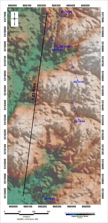
| Diamond Drill Hole Locations (See Figure 1) |
|||||
| Hole_ID | X | Y | AZ | Dip | Depth |
| SD-14-01 | 668306.4 | 5316786 | 317.5 | -62 | 127.69 |
| SD-14-02 | 668306.7 | 5316786 | 328 | -65 | 231 |
| SD-14-03 | 668441.6 | 5316567 | 340.1 | -62 | 309 |
| SD-14-04 | 668449.3 | 5316300 | 340 | -65 | 330 |
| SD-14-05 | 668364.9 | 5317013 | 234 | -47 | 234 |
| SD-14-06 | 668205.3 | 5315775 | 345 | -45 | 342 |
Hole SD-14-05
Hole SD-14-05 appears to both connect and delineate the upper extension of high grade gold mineralization zones in the Surluga deposit. Connecting similar zones will show the potential for a continuous zone of high grade gold mineralization in this part of the deposit.
Hole SD-14-06
SD-14-06 has better defined the spatial extent of the ore identified in the southern portion of the Surluga deposit. SD-14-06 intersected a fault zone that may have offset the spatial location of the gold-bearing mineralization and understanding the identification of this fault zone will help optimize drill targeting in the southern portion of the Surluga deposit.
Red Pine Commences 2015 Drill Program
Based on the successful results of the 2014 drill campaign, Forages Rouillier Drilling has been mobilized and will begin a diamond drilling program on February 11, 2015. The program consists of 8 to15 drill holes totaling 2,000 to 4,000 metres.
Insights From 2014 Exploration Campaign
In addition to intersecting gold mineralization, the 2014 Drill Program provided the following points of interest:
- There are multiple gold-bearing shear zones, at multiple orientations, in the hanging wall of the Jubilee Shear Zone;
- at least two separate gold mineralization events at the Surluga Deposit have been identified;
- detailed structural logging of oriented core identified structural controls that are associated with the gold mineralization;
- multiple fluid pathways are controlling the distribution of gold mineralization;
- gold mineralization is associated with diagnostic alteration that is easily detectable with hand-held XRF technology; and
- gold distribution has been correlated with geophysical properties.
The Company is utilizing the information outlined above to identify the structural, geochemical, and lithological controls for mineralization on the Property. This information will then be used, in conjunction with geophysical and geological correlations to:
- further expand the Surluga Deposit;
- connect the Surluga Deposit with historical deposits on the Property and;
- identify new mineralized gold zones.
Wawa Gold Project Highlights
- Located in Wawa, Ontario, an area of significant historical and current gold exploration (since 1890's) and production (1902 to 1991);
- 172 patented and leased and unpatented mining claims within the McMurray Township, a total of 2,426 hectares;
- 182 claim units on crown land, a total of 2,912 hectares;
- Property hosted eight past producing mines with historic production of over 120,000 ounces (Watts, Griffis and McQuat, NI 43-101 technical report dated October 15, 2012);
- Inferred resource of 1,072,335 ounces at 1.49 grams per tonne gold contained in 22.355 million tonnes, open along strike and at depth;
- Proximity to established regional infrastructure (roads, rail, regional airport, high voltage power lines, water);
- Assumption agreement in place with Augustine Ventures (CSE: WAW) and Citabar.
On-site Quality Assurance/Quality Control ("QA/QC") Measures
Drill core samples are transported in security-sealed bags for analyses at Activation Laboratories Ltd. in Ancaster, Ontario. Individual samples are labeled, placed in plastic sample bags and sealed. Groups of samples are then placed into durable rice bags that are then shipped. The remaining coarse reject portions of the samples remain in storage at the Activation Laboratories Ltd. in Ancaster, Ontario as required in the event that further work or verification is needed.
Red Pine has implemented a quality-control program to comply with best practices in the sampling and analysis of drill core. As part of its QA/QC program, Red Pine inserts external gold standards (low to high grade) and blanks every 20 samples in addition to random standards, blanks, and duplicates.
Qualified Person
Quentin Yarie, P.Geo. is the qualified person responsible for preparing, supervising and approving the scientific and technical content of this news release and is responsible for overseeing all aspects of the company's exploration programs.
About Red Pine Exploration Inc.
Red Pine Exploration is a gold and base-metals exploration company headquartered in Toronto, Ontario, Canada. The Company's common shares trade on the TSX Venture Exchange under the symbol "RPX".
For more information about the Company visit www.redpineexp.com
The Mineral Resource is disclosed in the NI 43-101 compliant technical report titled "Amended Technical Review and Mineral Resource Estimate for the Jubilee-Surluga Property, near Wawa, Ontario, Canada for Augustine Ventures Inc." dated October 12, 2012 and prepared by Clifford J. Duke, P. Eng., Senior Associate Geological Engineer of Watts, Griffis and McOuat, Consulting Geologists and Engineers. The report is available on www.SEDAR.com under Augustine's profile.
Neither TSX Venture Exchange nor its Regulation Services Provider (as that term is defined in policies of the TSX Venture Exchange) accepts responsibility for the adequacy or accuracy of this release.
This News Release contains forward-looking statements. Forward-looking statements are statements which relate to future events. In some cases, you can identify forward-looking statements by terminology such as "may", "should", "expects", "plans", "anticipates", "believes", "estimates", "predicts", "potential" or "continue" or the negative of these terms or other comparable terminology. These statements are only predictions and involve known and unknown risks, uncertainties and other factors that may cause our or our industry's actual results, levels of activity, performance or achievements to be materially different from any future results, levels of activity, performance or achievements expressed or implied by these forward-looking statements.
Figure 1 Location of December 2014 Drill Holes
http://media3.marketwire.com/docs/991391_figure1.jpg
To view the images associated with this release, please visit the following links:
http://media3.marketwire.com/docs/991391_Hole1.jpg
http://media3.marketwire.com/docs/991391_Hole3.jpg
Contact Information:
Quentin Yarie
President & COO
(416) 364-7024
qyarie@redpineexp.com
Red Pine Exploration Inc.
Mia Boiridy
Investor Relations
(416) 364-7024
mboiridy@redpineexp.com