Dublin, May 20, 2026 (GLOBE NEWSWIRE) -- The "Geostationary Orbit (GEO) Remote Sensing, Imagery & Data Services - Global Strategic Business Report" has been added to ResearchAndMarkets.com's offering.
The global market for Geostationary Orbit (GEO) Remote Sensing, Imagery & Data Services was estimated at US$197.0 Million in 2025 and is projected to reach US$626.8 Million by 2032, growing at a CAGR of 18.0% from 2025 to 2032. This comprehensive report provides an in-depth analysis of market trends, drivers, and forecasts, helping you make informed business decisions. 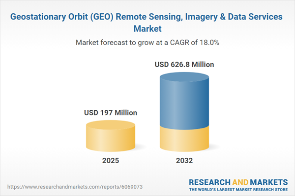
Which Industries Are Leveraging GEO Remote Sensing, Imagery & Data Services?
The applications of geostationary remote sensing extend across multiple industries, each leveraging its capabilities to enhance operational efficiency and strategic planning. The meteorological sector remains the largest consumer of GEO-based imaging, using it for real-time weather forecasting, early warning systems, and climate change modeling. Satellites such as GOES (Geostationary Operational Environmental Satellites) in the United States and Himawari in Japan provide continuous atmospheric data, enabling more accurate storm predictions and disaster response planning. The energy sector also utilizes GEO satellite data for monitoring offshore drilling operations, optimizing renewable energy production, and detecting methane emissions from industrial sites.
In the defense and intelligence sector, GEO remote sensing plays a crucial role in border surveillance, missile detection, and reconnaissance operations. Military agencies rely on geostationary satellites for persistent situational awareness, tracking enemy movements, and securing national infrastructure. Additionally, the agriculture industry is adopting GEO imagery for precision farming, crop health assessment, and water resource management, enhancing food security and sustainable farming practices. Telecommunications companies are also utilizing GEO satellites to improve network coverage, provide real-time geolocation services, and support the expansion of 5G infrastructure in remote regions. With industries becoming increasingly data-driven, the demand for high-resolution, real-time GEO imagery continues to rise.
What Are the Latest Technological Innovations in GEO Remote Sensing and Data Processing?
Recent advancements in geostationary satellite technology have significantly enhanced the accuracy, resolution, and analytical capabilities of remote sensing services. One of the most notable developments is the integration of high-resolution multispectral and hyperspectral imaging, allowing for detailed surface characterization and environmental monitoring. Modern GEO satellites are equipped with advanced radiometers, LiDAR sensors, and synthetic aperture radar (SAR) systems, improving their ability to detect atmospheric pollutants, track wildfires, and monitor deforestation trends in real time.
Additionally, cloud computing and AI-powered data processing are transforming how GEO remote sensing data is analyzed and disseminated. AI algorithms can now automatically process vast amounts of satellite imagery, identifying patterns and anomalies with greater speed and accuracy than traditional manual methods. Machine learning models are also enhancing the predictive capabilities of GEO-based weather forecasting and disaster mitigation efforts. Another critical innovation is the development of inter-satellite communication networks, allowing GEO satellites to relay data seamlessly to LEO constellations for enhanced global coverage. As demand for real-time, high-precision geospatial intelligence grows, these technological advancements are shaping the next generation of GEO-based remote sensing systems.
What Factors Are Fueling the Growth of the GEO Remote Sensing, Imagery & Data Services Market?
The growth in the geostationary orbit (GEO) remote sensing, imagery, and data services market is driven by several factors, including increasing demand for real-time Earth observation, advancements in AI-driven satellite analytics, and the expanding role of remote sensing in commercial and defense applications. The rising need for accurate weather forecasting and climate change mitigation has prompted governments and space agencies to invest in next-generation GEO satellites with enhanced imaging and atmospheric monitoring capabilities. The expansion of smart cities and digital infrastructure projects has also fueled demand for high-resolution geospatial data to optimize urban planning, transportation networks, and environmental sustainability initiatives.
Moreover, the growing integration of GEO imagery with big data platforms and cloud-based analytics has enhanced accessibility and usability for businesses and research institutions. The defense and security sector's reliance on persistent surveillance and threat detection has further contributed to market expansion, with increasing investments in advanced geospatial intelligence solutions. Additionally, private-sector participation in space exploration and satellite manufacturing has led to cost reductions in GEO satellite deployments, making high-quality remote sensing data more affordable for commercial enterprises. As technology continues to advance and industries recognize the strategic value of GEO-based remote sensing, the market is expected to experience sustained growth, driven by innovation, regulatory support, and increasing cross-sector adoption.
Report Scope
The report analyzes the Geostationary Orbit (GEO) Remote Sensing, Imagery & Data Services market, presented in terms of market value (US$). The analysis covers the key segments and geographic regions outlined below:
- Segments: Service (Imagery Service, Data Analytics Services); Deployment (Public Cloud Deployment, Private Cloud Deployment, Hybrid Cloud Deployment); Vertical (Agriculture Vertical, Forestry & Fishing Vertical, Mining Vertical, Engineering & Infrastructure Vertical, Energy & Power Vertical, Environment & Weather Monitoring Vertical, Maritime Vertical, Transport & Logistics Vertical, Aerospace & Defense Vertical, Other Verticals); End-Use (Commercial End-Use, Government & Military End-Use, Scientific & Academic Research End-Use).
- Geographic Regions/Countries: World; United States; Canada; Japan; China; Europe (France; Germany; Italy; United Kingdom; Spain; Russia; and Rest of Europe); Asia-Pacific (Australia; India; South Korea; and Rest of Asia-Pacific); Latin America (Argentina; Brazil; Mexico; and Rest of Latin America); Middle East (Iran; Israel; Saudi Arabia; United Arab Emirates; and Rest of Middle East); and Africa.
Key Insights:
- Market Growth: Understand the significant growth trajectory of the Imagery Service segment, which is expected to reach US$441.1 Million by 2032 with a CAGR of 19.5%. The Data Analytics Services segment is also set to grow at 14.9% CAGR over the analysis period.
- Regional Analysis: Gain insights into the U.S. market, valued at $60.9 Million in 2025, and China, forecasted to grow at an impressive 24.2% CAGR to reach $171.2 Million by 2032. Discover growth trends in other key regions, including Japan, Canada, Germany, and the Asia-Pacific.
Why You Should Buy This Report:
- Detailed Market Analysis: Access a thorough analysis of the Global Geostationary Orbit (GEO) Remote Sensing, Imagery & Data Services Market, covering all major geographic regions and market segments.
- Competitive Insights: Get an overview of the competitive landscape, including the market presence of major players across different geographies.
- Future Trends and Drivers: Understand the key trends and drivers shaping the future of the Global Geostationary Orbit (GEO) Remote Sensing, Imagery & Data Services Market.
- Actionable Insights: Benefit from actionable insights that can help you identify new revenue opportunities and make strategic business decisions.
Key Questions Answered:
- How is the Global Geostationary Orbit (GEO) Remote Sensing, Imagery & Data Services Market expected to evolve by 2032?
- What are the main drivers and restraints affecting the market?
- Which market segments will grow the most over the forecast period?
- How will market shares for different regions and segments change by 2032?
- Who are the leading players in the market, and what are their prospects?
Report Features:
- Comprehensive Market Data: Independent analysis of annual sales and market forecasts in US$ Million from 2025 to 2032.
- In-Depth Regional Analysis: Detailed insights into key markets, including the U.S., China, Japan, Canada, Europe, Asia-Pacific, Latin America, Middle East, and Africa.
- Company Profiles: Coverage of players such as Airbus Defence and Space, BAE Systems, BlackSky, Descartes Labs, EOS Data Analytics and more.
- Complimentary Updates: Receive free report updates for one year to keep you informed of the latest market developments.
Some of the companies featured in this Geostationary Orbit (GEO) Remote Sensing, Imagery & Data Services market report include:
- Airbus Defence and Space
- BAE Systems
- BlackSky
- Descartes Labs
- EOS Data Analytics
- EUMETSAT
- GHGSat
- ICEYE
- L3Harris Geospatial
- Maxar Technologies
- Mitsubishi Electric
- Northrop Grumman
- OHB SE
- Planet Labs
- Satellogic
- SatSure
- SkyWatch
- Spire Global
- Spot Image (Airbus)
- Thales Alenia Space
Domain Expert Insights
This market report incorporates insights from domain experts across enterprise, industry, academia, and government sectors. These insights are consolidated from multilingual multimedia sources, including text, voice, and image-based content, to provide comprehensive market intelligence and strategic perspectives. As part of this research study, the publisher tracks and analyzes insights from various domain experts. Clients may request access to the network of experts monitored for this report, along with the online expert insights tracker.
Key Attributes
| Report Attribute | Details |
| No. of Pages | 488 |
| Forecast Period | 2025-2032 |
| Estimated Market Value (USD) in 2025 | $197 Million |
| Forecasted Market Value (USD) by 2032 | $626.8 Million |
| Compound Annual Growth Rate | 18% |
| Regions Covered | Global |
MARKET OVERVIEW
- Trade Shocks, Uncertainty, and the Structural Rewiring of the Global Economy
- How Trump's Tariffs Impact the Market? The Big Question on Everyone's Mind
- Geostationary Orbit (GEO) Remote Sensing, Imagery & Data Services - Global Key Competitors Percentage Market Share in 2026 (E)
- Competitive Market Presence - Strong/Active/Niche/Trivial for Players Worldwide in 2026 (E)
MARKET TRENDS & DRIVERS
- Growing Demand for Persistent, High-Coverage Earth Observation Fuels Adoption of GEO Remote Sensing Platforms
- Expansion of Weather Forecasting and Climate Monitoring Applications Drives Demand for GEO-Based Imagery
- Increasing Need for National Security, Maritime Surveillance, and Border Monitoring Enhances GEO System Relevance
- OEM Innovation in Multispectral and Infrared Sensors Strengthens Business Case for GEO Remote Sensing
- Integration with AI and Cloud Analytics Enhances Real-Time Image Processing and Decision-Making Capabilities
- Rising Adoption of GEO Data Services in Disaster Management and Emergency Response Supports Market Growth
- Emerging Use Cases in Agricultural Monitoring, Forestry, and Urban Planning Expand Addressable GEO Data Markets
- Government Investments in Space-Based Infrastructure and EO Missions Stimulate Demand for GEO Data Services
- Growing Role of GEO Imagery in Environmental Compliance and Carbon Monitoring Drives Regulatory Adoption
- Interoperability Between GEO and LEO Systems Enhances Multi-Orbit Data Integration for Global Coverage
- Increased Use of Open Data Platforms and Public-Private Partnerships Expands Access to GEO Sensing Solutions
- Technological Advancements in On-Orbit Data Compression and Transmission Improve System Efficiency
- Wider Application in Infrastructure Monitoring, Asset Tracking, and Energy Sector Operations Creates B2B Opportunities
For more information about this report visit https://www.researchandmarkets.com/r/i63vzq
About ResearchAndMarkets.com
ResearchAndMarkets.com is the world's leading source for international market research reports and market data. We provide you with the latest data on international and regional markets, key industries, the top companies, new products and the latest trends.
Attachment
